AI for Climate Change Adaptation
The year 2024 was the hottest ever recorded in the world according to the World Meteorological Organization. The consequences of this climate change are devastating and are set to intensify in the coming years. The reference warming trajectory for climate change adaptation currently anticipates an average temperature increase in France of +4 °C by the end of the century. This is why, in addition to taking measures to mitigate this warming, we must act in favor of the adaptation of our territories. This is the challenge of the 3rd National Climate Change Adaptation Plan (PNACC), which was published in March 2025.
This planning, which is structured around actions for the adaptation of French territories, provides in measure 51 for mobilizing artificial intelligence solutions to serve climate change adaptation.
Artificial Intelligence in Service of Climate Change Adaptation in Territories (Practical Guide)
This guide is intended for local authorities and other project leaders, to assist them in implementing AI projects for climate change adaptation.
The Green Fund can be requested for financing AI projects carried out by local authorities.
More details here: https://www.ecologie.gouv.fr/dossiers/fonds-vert-accelerer-transition-ecologique-territoires/cahiers-vous-accompagner-chacun
Call for Projects “Frugal AI Demonstrators in Service of Ecological Transition in Territories” (DIAT)
The Ministry of Ecological Transition, Biodiversity, Forests, the Sea, and Fishing, and the Ministry of Land Use Planning and Decentralization have piloted the France 2030 call for projects “Frugal AI Demonstrators in Service of Ecological Transition in Territories” (DIAT). It concerns the real-world use of data science and artificial intelligence technologies in a frugal approach, aiming to improve the management of policies and public services and to serve the ecological transition of territories.
What is a frugal AI demonstrator?
- A technology of AI (computer vision, machine learning, anomaly detection, etc.) for prediction, decision support, classification, optimization or content generation.
- A favorable environmental assessment, with the justification of a benefit for the ecological transition of the territory greater than the environmental cost of the deployed solution (training of models, manufacturing of equipment, data storage, etc.).
- A response to the needs of territories for ecological transition: consortia led by local authorities (or their groupings), territorial public institutions or even emerging actors (companies less than 12 years old) associated with a territorial public actor.
- A focus on the replicability of the solution: thinking in advance about the interoperability of the developed system and its application in diverse contexts.
Winners of the Call for Projects “Frugal AI Demonstrators in Service of Ecological Transition in Territories”
The 4 winners of wave 1 were announced on June 7, 2023 (press release) and the 8 winners of wave 2 were announced on May 22, 2024 (press kit).
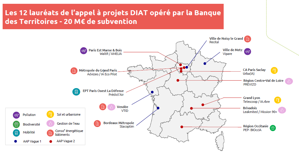
Leader/Project name: City of Metz/ViPARE
Consortium members: Naia Science, Water Environment Laboratory
The Vipare project helps local authorities measure and quantify the impact of their cleaning actions (and other investments in terms of cleanliness), in order to identify areas for improvement in public sanitation. To do this, it is based on the development of a mobile application, a system for retrieving geolocated data, and a mapping tool to track the amount of waste around road axes/waste hotspots. The project relies on AI to identify waste through video capture, with the algorithm designed to be executed from a smartphone to minimize data exchanges in a frugal approach.
Leader/Project name: Vendée Numérique
Consortium members: GIP Vendée Numérique, Géofit, Trivalis, Vendée Eau, Sydev, GéoVendée, department of Vendée
The project aims to optimize data management for all levels of territorial public services by providing quality, shared data, with uniqueness guaranteed at the departmental level to feed dashboards and decision-making tools for public policies. The project will lead to the creation of a digital twin of Vendée developed using AI-classified LIDAR data to create a high-precision solar cadastre.
Leader/Project name: Bordeaux Métropole/STACOPTIM
Consortium members: DRYAS, Kocliko, Domofrance, and ENERLAB
The project aims to implement and manage a decision support tool in the choice of construction or renovation policies allowing the identification of the most relevant scenarios following a multicriteria approach (cost, energy, CO2, comfort). It also aims to systematically measure and verify energy savings resulting from the implementation of energy performance improvement actions (works or operation of installations) and, if necessary, provide an explanation for discrepancies.
Leader/Project name: City of Noisy-le-Grand/RECITAL
Consortium members: EDF, Erinadis, Efficacity
The RECITAL project aims to complement existing data collection on the platform set up by the City of Noisy-le-Grand by creating an “energy hub” with the goals: In the short term, to manage and reduce daily energy consumption in buildings managed by the city; In the medium-long term, to allow a classification of the 200 buildings in the city which will prioritize energy renovations to achieve the largest possible energy and GHG emission savings as quickly as possible.
Leader/Project name: Advizeo (emerging actor)/IA Eco Pilot
Consortium members: Gridfit, Métropole du Grand Paris.
This project aims to develop a solution to automate the monitoring and management of buildings remotely in order to reduce energy consumption, while including an energy flexibility offer. AI enables the development of automated action plans (equipment adjustment and renovation works) that respond as efficiently as possible to the energy consumption reduction objectives of the tertiary decree, and to propose the most optimal regulation of installations and energy reduction (temporary reduction of electrical consumption, particularly during peak consumption).

Leader/Project name: WaltR / AMELIA
Consortium members: BRUITPARIF, IFPEN, G.Eiffel University, Public Territorial Establishment Paris Est Marne et Bois.
This project aims to use AI to better monitor and reduce air pollution and noise. Mobility is here the main lever for developing, implementing, and monitoring actions to reduce these nuisances. The project develops low-cost mobility and environmental mapping tools in terms of computation and storage to assist in territorial planning.
Leader/Project name: Telescoop / IA.rbre
Consortium members: Métropole de Lyon, UMR LIRIS (Lumière Lyon 2 University, CNRS, Claude Bernard Lyon 1 University, INSA Lyon, and École Centrale de Lyon).
This project aims to help planners to green their territories, thus combining the issues of planting, soil de-sealing, and urban cooling. The project aims to create a chain of tools and a methodology for analyzing, visualizing, and cross-referencing existing territorial data to locate plantable areas (degrees and types of plantations). The objective is to help local authorities to green their territories and, more generally, to facilitate the adaptation of cities to climate change and heat waves.
Leader/Project name: Leakmited / Mission 90+
Consortium members: Leakmited, Brivadois Water Management Union
This project aims to use AI to improve and generalize leak detection in the water network through sound sampling and enhance predictive maintenance to prevent water losses.
Leader/Project name: Public Territorial Establishment Paris Ouest La Défense / Predict AI’r
Consortium members: IFPEN, Citepa, Orange, AIR&D.
This project aims to develop a dynamic and predictive observatory of mobility and its impacts on air and climate. AI is used to process the volume of mobile phone billing data and to provide services to quantify daily the impact of mobility on climate and air quality, to support public decision-making.
Leader/Project name: Paris-Saclay Urban Community/Urba(IA)
Consortium members: BuildRZ, Centrale Supelec, Dassault Systèmes, Paris Region Institute, NamR.
This project aims to use AI to better take into account ecological issues in a context of increasing complexity in urban planning rules: improving the management of PLUs and tracking the environmental objectives of the Ile-de-France Master Plan. The project tests AI-assisted urban planning scenarios based on key ecological parameters.
Leader/Project name: Occitanie Region / PEP-BIOccIA
Consortium members: OpenIG, CNRS, TerrOïko.
This project aims to use AI to map natural environments (fauna/flora) and predict species presence. The freely accessible data will be used to monitor public policies in favor of biodiversity and will target various actors (planners, researchers, institutional actors, etc.). The objective is to plan for the preservation of biodiversity in Occitanie in the medium and long term, linked to European, national, and regional scales.
Leader/Project name: Centre-Val de Loire Region / Previz’O
Consortium members: Antea France, BRGM, LabIA, PRISME Laboratory, SMO Val de Loire Numérique, New Space of Cher, Tours Métropole
This project aims to use AI to predict episodes of tension on water resources in order to better foresee the quality and quantity of water, to anticipate adaptation measures.